Climate is one of the most important influences on a wine, alongside grape variety, soil and winemaking, so understanding it helps us understand Sardinia’s wines. In a previous post I explained that Sardinia has a warm Mediterranean climate. “Mediterranean” means mild, wetter winters and hot, dry summers: most of the rain falls between autumn and spring, leaving the summer largely dry. “Warm” refers to the growing season temperature (GST), a common measure calculated as the mean temperature over the growing season, which in the northern hemisphere runs from April to October. In the WSET classification, a GST between 18.5°C and 21°C (65–70°F) is considered warm, and anything above 21°C is hot. That holds for the island on average, but the picture is changing: over the last decade, a growing number of locations have crossed the 21°C threshold.
Sardinia is also big and varied. At about 24,000 km², it is larger than Tuscany or Slovenia and not far from Sicily. Latitude, altitude, slopes, distance from the sea, sunshine, winds and rainfall combine to create very different conditions from one place to another, and these differences have a real impact on wine production.
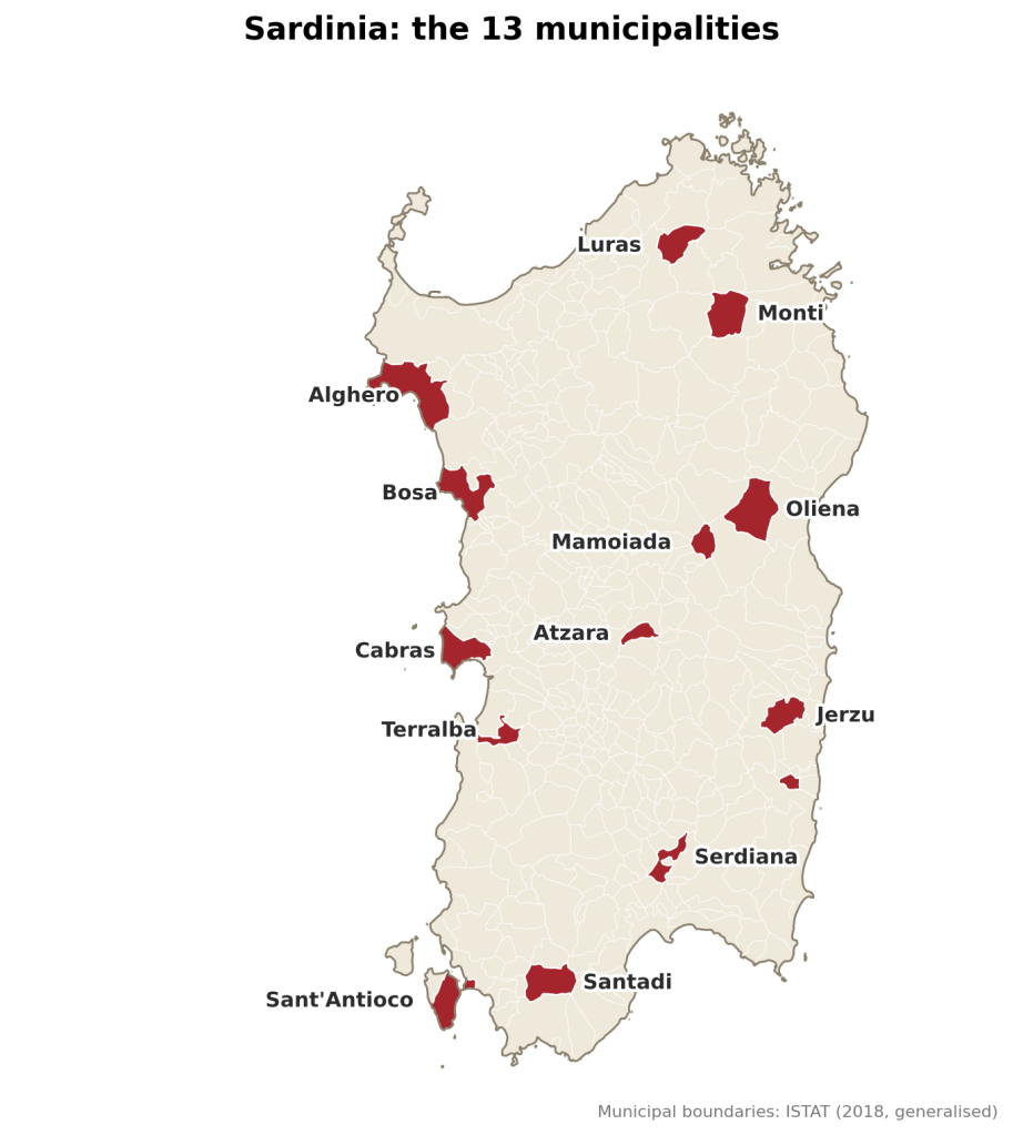
13 representative locations
In this post I explore how these factors play out in 13 representative locations, and what they tend to mean for the grapes grown there. I started from the seven municipalities with the largest vineyard area in Sardinia, according to the regional agency Laore (2024): Alghero, Serdiana, Oliena, Sorso, Dorgali, Monti and Jerzu. I set aside Dorgali and Sorso, which are close in altitude, exposure and position to Oliena and Alghero, and added eight municipalities that are important or iconic for winemaking and give an even geographical coverage of the island’s microclimates: Cabras, Terralba, Bosa, Santadi, Sant’Antioco, Atzara, Mamoiada and Luras. All 13 are compared with the same dataset, so the comparison is on equal terms (details in the data and method section at the end).
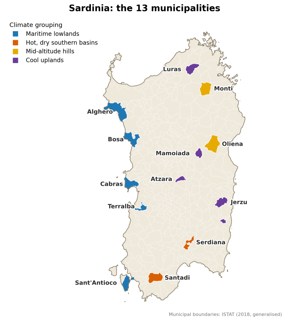
Four climatic groups
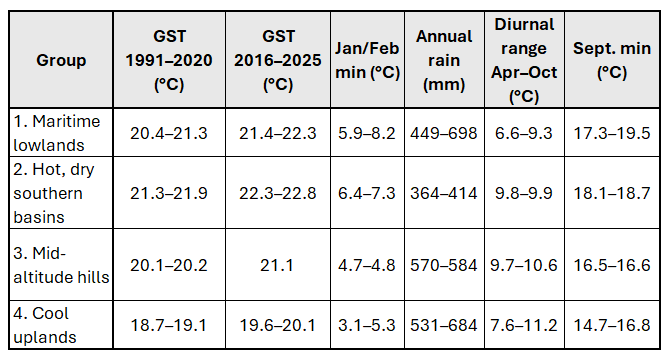
Looking at the numbers together (growing season temperature, winter minimums, rainfall and exposure to the sea), the 13 locations fall into four broad groups. Climate shapes the tendencies of each group, but grape variety, soil, vine age, yields and winemaking shape the wines just as much, so none of what follows is a rule about how a wine will taste. The values for Jerzu and Atzara are adjusted to town altitude, as explained in the note under the tables.
1. The maritime lowlands (Alghero, Bosa, Cabras, Terralba, Sant’Antioco)
- Typical grapes: Vermentino, Torbato (Alghero); Malvasia (Bosa); Vernaccia (Cabras); Bovale Sardo (Terralba); Carignano (Sant’Antioco).
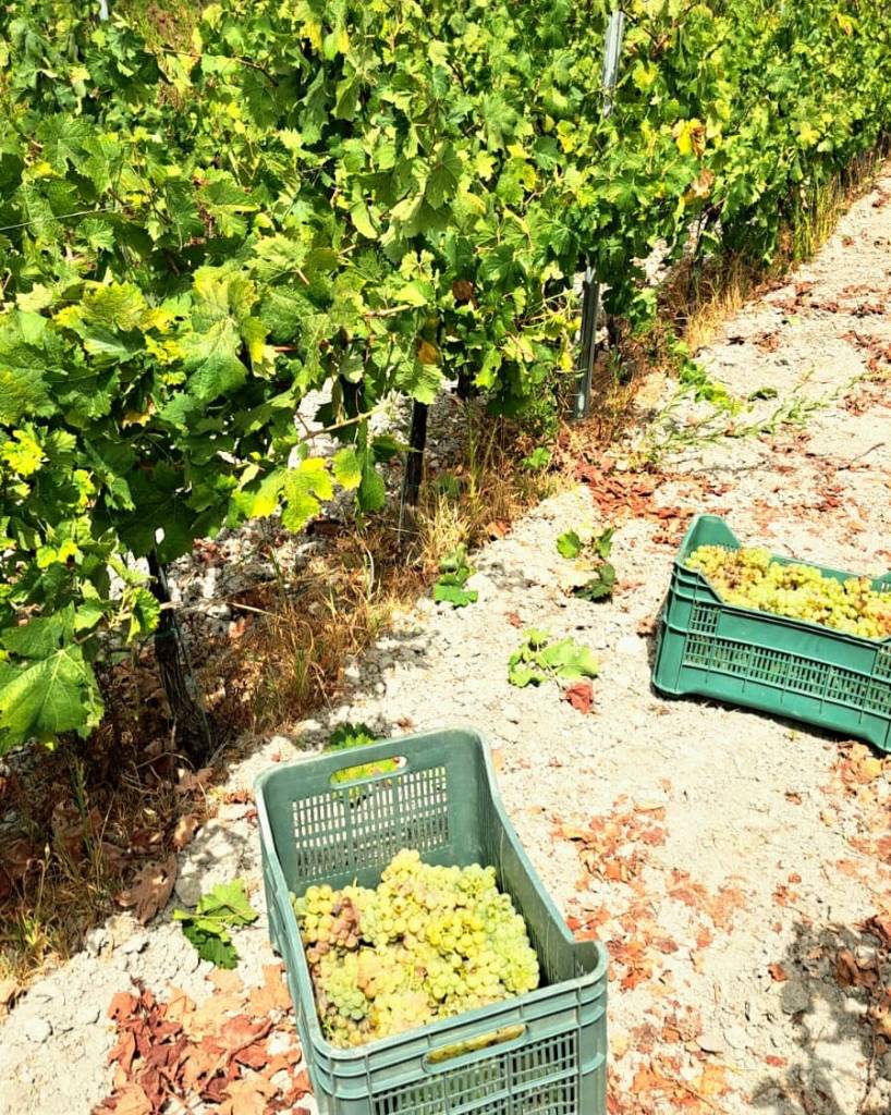
- Ripening window: expect the earliest harvests of the island. Depending on the grape varieties and intended wine style, it can already be during the second half of August.
- Climatic profile: sea-level sites (6–10 m) with mild winters and the smallest diurnal ranges. September nights are warm, and the Maestrale blows on 22–47% of April–October days, most often at Terralba and Sant’Antioco. Rainfall ranges from 449 mm (Sant’Antioco) to 698 mm (Bosa). Alghero is the clearest case of the sea acting as a heat sink, with the narrowest diurnal range on the list (6.6°C) and the mildest winter (8.2°C minimum). Terralba, about 10 km from the sea, still behaves like a coastal site, so the sea’s influence reaches well inland across the Gulf of Oristano plain.
- What this tends to mean: warm nights speed up the loss of acidity, so harvest timing is critical and early picking is common to keep freshness. The Maestrale cools and dries the vineyards. Sant’Antioco is the hottest and driest of the group and sits closer to the southern basins in heat.
- Examples on this blog: Dominariu; Karmis; AD 49; Akenta Cuvée; I Giganti Bianco; Contini Flor.
2. The hot, dry southern basins (Santadi, Serdiana)
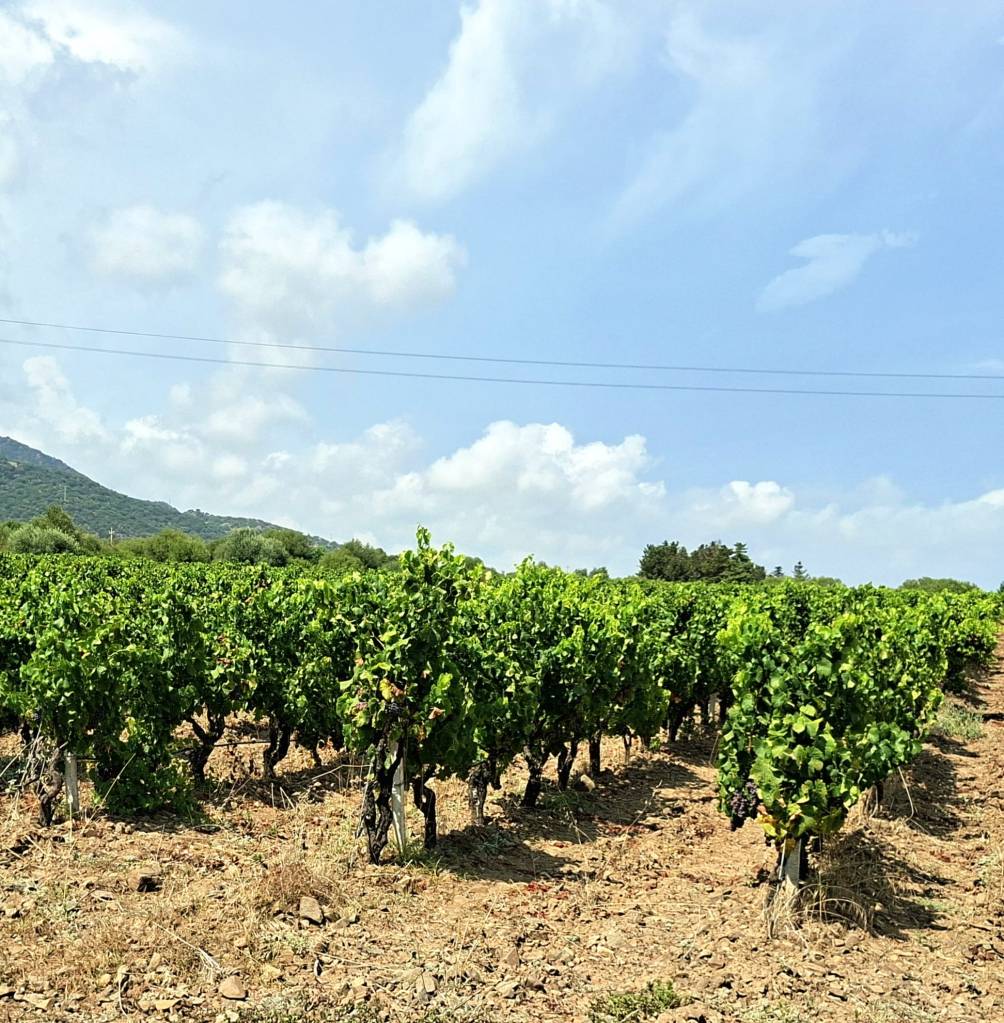
- Typical grapes: Carignano (Santadi); Cannonau, Monica, Nuragus, Nasco (Serdiana).
- Ripening window: depending on the grape varieties and intended wine style, harvest can already be during the second half of August.
- Climatic profile: the warmest and driest locations, at about 135 m. GST is 21.9°C at Santadi and 21.3°C at Serdiana, July–August maximums average 32.5°C and 31.9°C, and Santadi sees about 13 days a year above 35°C. Rainfall is the lowest of the 13 locations (414 and 364 mm, with only 147–177 mm in the growing season), and the heat-accumulation measures are the highest in the dataset (Huglin index 2,730 at Santadi).
- What this tends to mean: a high risk of water stress and sunburn in heat waves, which is one reason traditional bush training (alberello) and careful canopy management matter here. Climate favours ripe, full-bodied styles, with freshness depending on altitude, breezes (the Maestrale on 29–36% of days) and harvest timing.
- Examples on this blog: Montessu; Iselis Rosso; Pedraia; Bessiu.
3. The mid-altitude hills (Monti, Oliena)
- Typical grapes: Vermentino di Gallura (Monti); Cannonau (Oliena, within the Nepente di Oliena sub-zone).
- Ripening window: depending on the grape varieties and intended wine style, harvest is not normally expected to start before the end of August.
- Climatic profile: at 300–378 m, with cold winters and a wide swing between day and night at Monti (10.6°C). Summer days are nearly as hot as in the south (July–August maximums of 31.0–31.4°C, and 7–11 days a year above 35°C), which makes Monti a surprise given its cooler average. Rainfall is 570–584 mm, with 45–48% falling in the growing season, and the prevailing wind is from the west.
- What this tends to mean: summers as hot as the lowlands but cooler nights and winters, so the vines accumulate less heat overall (Winkler index about 2,170–2,180, against 2,230–2,540 for the lowlands and southern basins). That can allow a balance between ripeness and acidity, with growing-season rain and wind as the factors that matter most for vineyard health.
- Examples on this blog: Biriai; Gran Rosé; Zojosu.
4. The cool uplands (Jerzu, Atzara, Mamoiada, Luras)
- Typical grapes: Cannonau (Jerzu, Mamoiada); the Mandrolisai blend of Bovale Sardo, Cannonau and Monica (Atzara); Vermentino di Gallura (Luras).
- Ripening window: depending on the grape varieties and intended wine style, harvest is not normally expected to start before the first half of September.
- Climatic profile: between 427 and 644 m (Mamoiada is the highest town on the list), with the lowest GST and the coldest winters (Atzara 3.1°C and Mamoiada 3.3°C minimums). Atzara is also the furthest from the sea, about 47 km in a straight line. September nights are cool and the Winkler index is the lowest (1,866–1,953). Diurnal ranges are wide at Atzara (11.2°C) and Mamoiada (10.3°C), but not at Jerzu (7.6°C), probably moderated by sea air from the nearby east coast, which makes it the least typical of the four. About half of the 531–684 mm of annual rain falls between April and October, and the wind is mostly from the west.
- What this tends to mean: slower ripening and later harvests, which tend to preserve acidity and give time for tannins and colour to mature. In a warming climate these cooler sites may become increasingly valuable, since they are the only places still in the WSET warm band after the last decade.
- Examples on this blog: Tott’unu; Nughes; Granazza.
What the numbers show
- Cool nights before harvest. Mean minimum temperatures in September (the cool night index) range from 14.7°C in Atzara to 19.5°C in Alghero. Values above about 18°C are commonly treated as warm nights, which is the case for most of the coast and the south. The hills and uplands (14.7–16.8°C) keep their nights cooler, which helps preserve aromatics and acidity.
- Warming. Over 1991–2020, GST ranges from 18.7°C (Mamoiada and Luras) to 21.9°C (Santadi), so most locations sit in the WSET warm band and three (Santadi, Sant’Antioco and Serdiana) are already hot. Every town is 0.9–1.0°C warmer in 2016–2025, and nine of 13 now exceed 21°C. Only the cool uplands remain in the warm band.
- Rainfall. The south is clearly the driest part of the island: Serdiana (364 mm), Santadi (414 mm) and Sant’Antioco (449 mm). The wettest are Bosa (698 mm), Atzara (684 mm) and Alghero (658 mm), so the pattern is more west-to-south than lowland-to-mountain. What does change with altitude is the timing: the hills and uplands receive 45–50% of their rain between April and October, against 38–43% for the lowlands and southern basins. That extra growing-season rain is more help against summer drought stress than the totals suggest.
- The diurnal range. Only three locations have a growing-season swing above 10°C: Atzara (11.2°C), Monti (10.6°C) and Mamoiada (10.3°C). A wide swing slows sugar accumulation and helps preserve acidity.
Conclusion
Sardinia’s climate is not one climate but several. Within a few dozen kilometres, a location can move from a sea-buffered coast to a hot, dry basin or a cool upland, and the grapes, harvest dates and styles move with it. These contrasts are also shifting. Compared with 1991–2020, the last decade has been about 1°C warmer almost everywhere, and nine of the 13 locations I looked at now average above 21°C in the growing season, the point at which WSET classes a climate as hot. The cool uplands of the interior (Jerzu, Atzara, Mamoiada and Luras) are the only ones still in the warm band. Whether that makes them increasingly valuable, and how growers elsewhere on the island adapt, are questions I’ll keep following in the tasting notes and in this series.
Data and method
To compare the 13 locations on equal terms, I used one dataset for all of them rather than a patchwork of different station records. Temperatures come from ERA5-Land reanalysis (Copernicus/ECMWF, accessed through Open-Meteo), and rainfall and wind from the coarser ERA5. All figures are averages for 1991–2020 unless stated otherwise; the last-decade GST (2016–2025) is shown in Table B. Growing season temperature (GST) is the April–October mean. The diurnal range is the average gap between daily maximum and minimum temperatures over the same months, and the Huglin index and Winkler degree days are two standard measures of heat accumulation during the growing season. The wind data are averages of daily maximum speeds, not true mean speeds.
One caveat: the figures refer to the altitude of each town, but vineyards often sit well above or below it, and a municipality can span hundreds of metres (Atzara, for example, ranges from 217 to 786 m). The numbers describe each area in general rather than any single vineyard.
Table A: climate
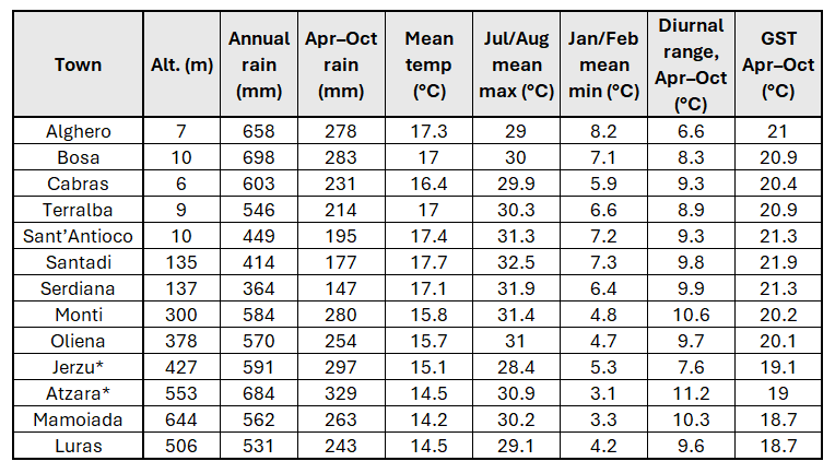
Table B: heat accumulation, recent warming and wind
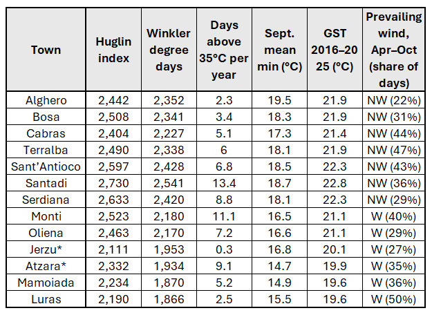
Note to the tables: values marked with an asterisk were adjusted to the altitude of the town using a standard lapse rate of 0.65°C per 100 m. These are simplifications based on town altitude, while the altitude of a whole municipality can vary significantly. Rainfall comes from a dataset with a coarse grid (about 25 km) and should be read as indicative: it smooths the contrast between coast and mountains.


Leave a Reply